I.
Acknowledgement of Condition
Donor: Weyerhaeuser Company Limited
Covenant Area: the entire parcel listed below:
|
Parcel Identifier
|
Legal Description
|
|
000-913-961
|
NE º Section 3 Excluding S10Ch of W10Ch, Sayward District
|
which is shown outlined in heavy (red) line on the plan
attached hereto at Exhibit A as Map 1 (the “Property”).
The Donor and Donee agree that the state of the Property as
at the date of completion of the field observations for this report, being
November 13, 2002, was as detailed in this report.
Donor:
|
Weyerhaeuser Company Limited
|
|
|
Per:
|
|
Date:
|
|
|
|
Authorized Signatory
|
|
|
Donee:
|
The Nature Trust of British Columbia
|
|
|
Per:
|
|
Date:
|
|
|
|
Don Lane, Administrative Director
|
|
|
The undersigned acknowledge having prepared this report and
hereby confirm that the attached information provides an accurate
representation of the Property on November 13, 2002.
By: ____________________________________ Date:
____________________
Kevin
Haberl, R.P.F.
By: ____________________________________ Date:
____________________
Ken
MacKenzie, R.P.Bio
TABLE OF CONTENTS
I. Acknowledgement
of Condition.......................................................................................... 2
II. Summary
Information....................................................................................................... 5
A. Property
Information........................................................................................................ 5
1. Donor: Weyerhaeuser Company Limited........................................................................ 5
2. Location: E of Smelt Bay, Cortes Island........................................................................ 5
3. Easements or existing Rights-of-Way of Record:
Sutil Point Road Right of Way, Smelt Bay Road Right of Way, Highfield Road
Right of Way, Seascape Road Right of Way, Hydro/Telephone lines within road
Rights of Way........................... 5
B. Introduction....................................................................................................................... 5
C. Methods.............................................................................................................................. 5
III. Ecosystem
Characteristics............................................................................................ 6
A. Overview............................................................................................................................. 6
B. Ecosystem
description....................................................................................................... 6
C. Soil
Erosion Risk.............................................................................................................. 8
D. Rare
Plant Species And Plant Communities................................................................. 8
IV. Wildlife
Characteristics............................................................................................... 8
A. Overview:........................................................................................................................... 8
B. Wildlife
Trees.................................................................................................................... 9
C. Habitat
Description........................................................................................................... 9
V. Human-Engineered
Features......................................................................................... 10
A. Roads................................................................................................................................. 10
1. Smelt Bay Road............................................................................................................. 11
2. Sutil Point Road............................................................................................................. 11
3. Highfield Road............................................................................................................... 11
4. Seascape Road............................................................................................................... 11
5. Six old loose surface private access roads as
mapped in Exhibit A............................... 11
B. Bridges.............................................................................................................................. 11
C. Hydro
Lines...................................................................................................................... 11
VI. Key
Attributes................................................................................................................ 11
A. Synopsis........................................................................................................................... 11
1. Ecologically significant habitat...................................................................................... 11
2. Rare plant species.......................................................................................................... 11
3. Rare wildlife species...................................................................................................... 11
4. Watercourses................................................................................................................. 11
5. Wetlands........................................................................................................................ 12
6. Wildlife trees.................................................................................................................. 12
B. Wildlife
Tree Management - Background................................................................... 12
VII. Photographs:
On-site and Aerial................................................................................ 12
VIII. Maps.................................................................................................................................. 13
IX. Recommended
Monitoring............................................................................................. 13
X. Caveat.............................................................................................................................. 13
XI. References....................................................................................................................... 13
EXHIBIT
"A" Maps..................................................................................................................... 15
EXHIBIT
"B" Vegetation List................................................................................................. 20
EXHIBIT
"C" Aerial Photograph........................................................................................... 21
EXHIBIT
"D" Photographic Documentation........................................................................ 22
II.
Summary Information
A.
Property Information
1.
Donor: Weyerhaeuser Company Limited
2.
Location: E of Smelt Bay, Cortes Island.
3.
Easements or existing Rights-of-Way of Record: Sutil Point Road
Right of Way, Smelt Bay Road Right of Way, Highfield Road Right of Way,
Seascape Road Right of Way, Hydro/Telephone lines within road Rights of Way.
B.
Introduction
This
baseline report documents the condition of the Property, including description
of ecosystem characteristics, wildlife characteristics, and human-engineered
features such as roads and power-lines. In addition, key attributes that are
significant for land management and development are described. This includes
ecologically significant habitats, rare plant species, rare wildlife species,
watercourses, wetlands, and wildlife trees. The baseline report describes
conditions of the Property as of November 13, 2002.
C.
Methods
The ecosystem, wildlife, and
human-engineered features of the Property were assessed for the purposes of
this report during a site visit conducted November 12 and 13, 2002. This
visit was done by Kevin Haberl of B.A. Blackwell and Associates Ltd., North
Vancouver, B.C., and by Ken MacKenzie of Iverson and MacKenzie Biological
Consulting Ltd., Lac la Hache, B.C.
Prior to field visits, aerial
photographs were viewed and areas with high potential for significant habitats
were noted. All existing maps and a wildlife observation database (Ministry of
Water, Land, and Air Protection) were reviewed. In addition, lists of rare
plant and animal species, rare plant communities,
and a database of local element occurrences (Ministry of Sustainable Resource
Management) were reviewed. Any waterbodies, wetlands, rocky areas or natural
open areas were noted and planned for viewing. The Property was thoroughly
traversed on foot and any habitat features seen were noted. Any permanent
habitat features including caves, cliffs, wetlands, and open water bodies were
mapped and habitat quality for each of the evaluated species was rated.
Wildlife trees were evaluated
during the field evaluation and mapped into areas of relatively consistent
densities.
Ecosystem features including
vegetation and soils were observed while traversing the Property on foot, and
through data collected from twenty-four ecosystem assessment plots. These
plots were a combination of full reconnaissance-level plots (KH plots) and
quicker soil and vegetative description plots (K plots). The information
gathered from the plots included data on physiography, soils (through
excavation of a soil pit), understory vegetation and overstory tree species
(modified from B.C. Min. of Env., Lands, and Parks, and B.C. Min. For. 1998).
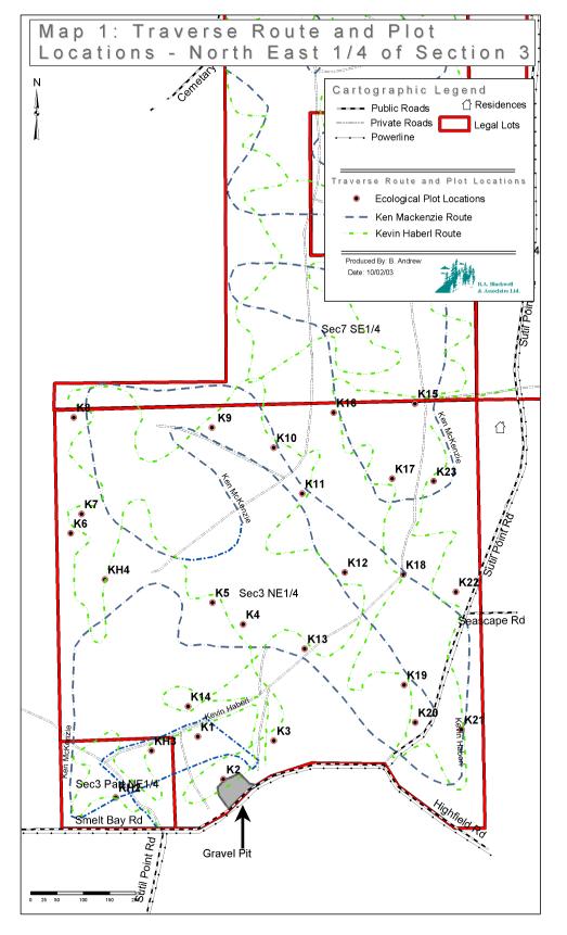
See Map 1 at Exhibit A for the traverse route and plot locations.
Selected features of the Property
were photographed and are documented in the Photographic Documentation in
Exhibit D.
III.
Ecosystem Characteristics
A.
Overview
The Property is a generally square shape bounded on the
north side by an open canopy commercially thinned young forest, on the south by
Smelt Bay Road, Sutil Point Road, and Highfield Road, on the west by private
property, and on the east by private lots on Sutil Point Road or closed canopy
young forest. The topography is uniform, even, and generally flat to rolling,
and ranges in elevation from a low of 35m in the southeast to a high of 70m
along the north edge. Soils were observed in roadcuts and at soil pits at many
plot locations. The soil parent materials are predominantly deep glaciofluvial
outwash, occasionally with a glaciomarine cap overlaying coarser materials.
These soils are deep, coarse textured and rapidly drained except where
impermeable layers occur and drainage is restricted. Root zone soil textures
varied from LS (loamy sand) to S (sand) with coarse fragment content varying
from 20 to 50%. The forest cover is dominated by commercially thinned
second-growth Douglas-fir (Pseudotsuga menziesii) and western redcedar (Thuja plicata) with small components of red alder (Alnus
rubra), lodgepole pine (Pinus
contorta), and western hemlock (Tsuga
heterophylla). The majority of the forest
was established following logging in the 1930’s. There are approximately
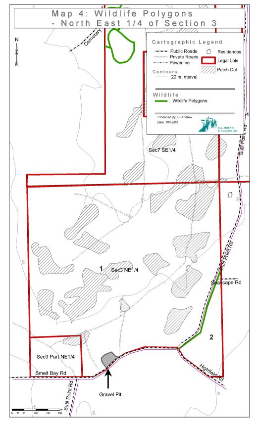
13 small patchcuts throughout the property (see Map 4, Wildlife Polygons).
B.
Ecosystem description[3]
This area falls within the Eastern Very Dry Maritime Coastal
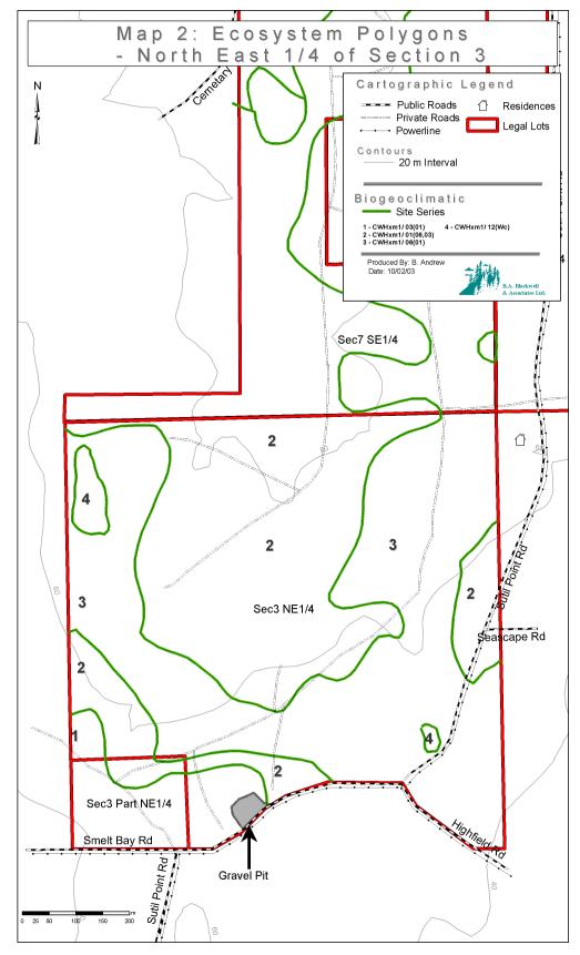
Western Hemlock biogeoclimatic variant (CWHxm1). The Property has been divided
into four different ecosystem polygons. An ecosystem polygon represents an
area featuring a characteristic structural stage (Table 1) and ecosystem or
pattern of ecosystems. Ecosystems are identified using site series recognized
in the biogeoclimatic ecosystem classification system. Refer to Map 2 for
location of the recognized ecosystem polygons.
TABLE 1. Forest structural stage
classes
|
Code
|
Class
|
Description
|
|
NV
|
Non-vegetated
|
< 10% cover of vascular plants
|
|
HB
|
Herb
|
herb dominated communities, <
10% tree cover, < 25% shrub cover
|
|
SH
|
Shrub/herb
|
< 20 year old forest, dominated
by shrubs <10 m tall including conifer regen, tree cover < 10%, < 20
years
|
|
PS
|
Pole/sapling
|
trees > 10 m tall and
overtopping shrub and herb layer, generally 20 to 40 years
|
|
YF
|
Young forest
|
self-thinning evident, canopy
layers developed, generally 40 to 80 years
|
|
MF
|
Mature forest
|
co-dominant trees mature, well
developed understory often including advanced regen, generally 80-250 years
|
|
OF
|
Old forest
|
old, structurally complex stands
with snags and CWD, generally >250 years
|
Ecosystem
Polygon 1 is predominantly site series 03 (FdHw – Salal site series, moderately
dry/nutrient poor) with a component of poorer site series 01 (HwFd – Kindbergia
site series, slightly dry/nutrient poor). The soils are coarse sand on top of
deep, coarse glaciofluvial outwash. The overstory is a generally Young Forest
structural stage dominated by Douglas-fir (Fd) with a component of lodgepole
pine (Pl). The overstory tree density is approximately 150 stems per hectare
following the commercial thinning. This polygon is located in two separate
units adjacent to the small property in the southwest corner of this property.
Ecosystem
Polygon 2 is predominantly site series 01 (HwFd – Kindbergia site series,
slightly dry-fresh/nutrient poor-medium) with a small component of site series
06 (HwCw-Deer fern site series, moist/nutrient poor-medium) and site series 03.
The soils consist of a loamy sand to sand, coarse glaciofluvial outwash, with
a rare glaciomarine cap of sand in a portion of the area. This polygon
generally slopes gently to the south or southeast. There is a healthy and
continuous cover of salal within this polygon, particularly in thinned areas.
The stand is a predominately commercially thinned Young Forest structural stage
comprised of Fd with a small component of western hemlock (Hw), and western
redcedar (Cw), with small portions of unthinned young forest scattered within
the polygon.
Ecosystem
Polygon 3 is predominantly site series 06 with a component of site series
01. The soil consists of deep glaciofluvial outwash with a rare glaciomarine
cap of sand in a portion of the area. This polygon has a moisture restricting
layer, resulting in moist soils with mottling. This ecosystem polygon has a
higher component of deciduous trees, particularly red alder (Dr), and supports
moderate forest productivity. The overstory is a commercially thinned Young
Forest structural stage comprised of Cw, Fd, and Dr.
Ecosystem
Polygon 4 is predominantly site series 12 with some small sedge-dominated
wet patches. The soil consists of deep glaciofluvial outwash with an organic
cap in most of the area. This polygon has a moisture restricting layer,
resulting in wet soils and scattered surface water. It is located in a broad
hollow near the northeast corner of the property, and in a small depression in
the southeast portion of the property. This ecosystem polygon has a higher
component of deciduous trees, particularly red alder (Dr). The overstory is a
commercially thinned Young Forest structural stage comprised of Cw, Hw and Dr.
C.
Soil Erosion Risk
Throughout the Property, soil parent materials are
predominantly deep, coarse textured glaciofluvial outwash materials on subdued
topography. No areas at significant risk of erosion were found on the Property.
D.
Rare Plant Species And Plant Communities
Rare species, which potentially may be found on Cortes
Island, were selected from the species database maintained by the Committee on
the Status of Endangered Wildlife in Canada (COSEWIC). Species
considered outside the range represented by the study area were excluded (e.g.
high elevation alpine areas, Interior of B.C.).
Rare plant communities, which potentially may be found on
Cortes Island, were obtained from the Conservation Data Center
(CDC) natural plant community tracking lists for the CWHxm1 biogeoclimatic
variant.
No rare plant species were
observed during the field examination, nor have been recorded in the CDC
element occurrence reports. As vegetation was not fully developed due to the
season, many of the listed species would not be visible. However, the
ecosystems in which the majority of these species are typically found did not
occur on the Property.
IV.
Wildlife Characteristics
A.
Overview:
Habitat
requirements were divided into habitats used for reproduction, and general
habitat used for the remainder of life history requisites. Generally,
reproductive habitats are more restrictive to a species than the general
habitat used for foraging or other life history requisites but often the
quality of reproductive habitat depends upon proximity to and quality of
adjacent foraging habitat.
Habitats for
evaluation were separated into permanent habitat and temporary habitat
attributes. Permanent habitats include such areas as cliffs, caves, streams,
wetlands and lakes (Table 2). These features were mapped when encountered,
described, areas of the habitat were estimated, and habitat value assigned. The
overall habitat rating for these permanent habitats was then modified to
reflect the quality of the surrounding foraging habitat.
Temporary
habitat attributes include such things as forest structure and wildlife trees,
and were described using structural stage (for forest structure) and density
for Wildlife Tree Classes.
TABLE 2. List of permanent habitats
associated with rare species potentially found on Cortes Island.
|
Habitat type
|
Designated species
|
|
Wetlands
|
northern red-legged frog
|
|
Caves/crevices
|
Keen’s long-eared myotis
|
|
Large Cliffs
|
Peregrine falcon
|
|
|
Peregrine falcon
|
|
Streams/ Riparian Vegetation
|
Keen’s long-eared myotis, northern red-legged frog,
barn owl, sharp-tailed snake
|
|
Shallow open water
|
northern red-legged frog
|
B.
Wildlife Trees
Wildlife trees were classified
based upon decay class and species as per the Wildlife Danger Tree Assessor’s
Course Handbook (6th ed., 2000) (Table 3). Signs of use increase quality
rating, as does both tree height and diameter. Western redcedar (Thuja
plicata) and Douglas-fir (Pseudotsuga
menziesii) were rated as the most valuable
wildlife tree species because of the longevity of standing dead trees of these
species. Any sign of use was noted during field assessments. High value
wildlife trees are defined as Wildlife Tree Classes 3, 4, 5 and, if there is
sign of wildlife use (cavities, usually meaning that part of the tree is dead)
Wildlife Tree Class 2. Wildlife Tree Class 6 and 7 trees and, if there is no
visible wildlife use, Wildlife Tree Class 2 trees are of lower value. This
rating is based both upon the expected longevity of the wildlife trees and on
their current habitat value.
TABLE 3. Wildlife Tree Classes1
|
Class
|
Description
|
|
1
|
Live, healthy,
no obvious decay
|
|
2
|
Live but
unhealthy, internal decay evident, declining, deformed
|
|
3
|
Recently
dead, wood sound, fine branches intact
|
|
4
|
Dead,
wood relatively sound, fine branches fallen but larger limbs intact
|
|
5
|
Dead,
wood becoming spongy, most limbs fallen, bark mostly intact
|
|
6
|
Dead,
wood soft, limbs fallen, more than half the bark fallen, greater than 2/3 of
tree height remaining erect
|
|
7
|
Dead,
wood soft, most of bark sloughed, less than 2/3 of tree height erect
|
1
modified from Wildlife Danger Tree Assessor’s Course Handbook, 2000
C.
Habitat Description
Wildlife species
and habitats evaluated on the Property were selected from the COSEWIC lists for
British Columbia. Species on the lists that are not affected by land
management practices (eg. whale species, sea otter) and species whose known
distribution does not approach Cortes Island (eg. grizzly bear, Vancouver
Island marmot) were deleted from the list of species to be evaluated. Habitat
requirements for the remaining species were then obtained from the literature.
Most of
the forests on the Property (Wildlife Polygon 1 on Map 4 in Exhibit A) has been
recently commercially thinned with approximately 100 to 200 stems per hectare
reserved. The small part east of Sutil Point Road had not been recently
harvested and the forest here is much denser than in the remainder of the
Property. This denser forest was differentiated from the remainder of the
Property for this reason (Wildlife Polygon 2 on Map 4 in Exhibit A). High
value wildlife trees and recruitment tree densities are generally low across
the entire lot although more large recruitment trees were seen in Polygon 2.
No
permanent habitat features were seen in the lot. The terrain is made up of
glaciofluvial outwash and is fairly level and not suitable for burrowing.
Occasional glacial erratic boulders were seen. No streams, wetlands,
significant shallow open water, or rock cliffs were noted. Current habitat
value for designated species is low. Few potential nest sites for
cavity-nesting species were found in the lot and foraging habitat is limited.
TABLE 4. Summary of wildlife habitat features
|
Polygon
|
Permanent
habitat (PH)
|
Value
of PH
|
Structural
stage (Table 1)
|
Density
of high values wildlife trees (Table 5)
|
|
1 –
thinned young forest
|
|
n/a
|
YF
|
1
|
|
2 –
unthinned young forest
|
none
|
n/a
|
YF
|
1
|
TABLE 5. Density and distribution
classes for wildlife tree assessment
|
Class
|
Distribution
|
|
1
|
a few sporadically occurring individuals
|
|
2
|
several sporadically occurring individuals
|
|
3
|
many uniformly distributed individuals
|
|
4
|
a single patch or clump
|
|
5
|
a few patches or clumps
|
|
6
|
several well-spaced patched or clumps
|
V.
Human-Engineered Features
A.
Roads
Smelt Bay Road is a paved all season public road located
immediately to the south of this Property. Sutil Point Road enters the
Property about midway along the east side and curves west within the property
before leaving it to run west along the south boundary at the intersection with
Highfield Road. This is also a paved all season public road. Highfield Road
and Seascape Road are both public roads that go southeast and east respectively
off of Sutil Point Road. Seascape Road is within the property for a short
distance. Highfield Road runs along part of the south boundary.
Several private roads are located within the Property.
Portions of these roads are very brushy. The private roads that are shown on
the maps in Exhibit A are generally driveable and have a compact road bed.
Sections of old access or logging roads can still be found, particularly related
to the ground-based commercial thinning of this property, but provide no access
and cannot now be considered roads. Access to these private roads is gated.
There
is a small shallow gravel pit located on the south edge of the property just
east of the Sutil Point Road/Smelt Bay Road junction. This pit is up to 2m
deep and approximately 70m east/west and 40m north south in dimension.
The
following summarizes the observed human engineered features:
1.
Smelt Bay Road
2.
Sutil Point Road
3.
Highfield Road
4.
Seascape Road
5.
Six old loose surface private access roads as mapped in Exhibit A.
6.
Gravel Pit on the south boundary
B.
Bridges
There are no bridges within the Property.
C.
Hydro Lines
There are power and telephone lines running the length of
Sutil Point Road, Highfield Road, and Seascape Road within this property.
VI.
Key Attributes
A.
Synopsis
This
section describes important features from the ecosystem and wildlife
characteristics, which are relevant for land management and development.
1.
Ecologically significant habitat
There
are no ecologically significant habitats within this property.
2.
Rare plant species
No rare plant species were found on the Property.
3.
Rare wildlife species
No rare
wildlife species or their habitats were found on the Property.
4.
Watercourses
There
are no watercourses on this property.
5.
Wetlands
No significant wetlands were seen on the Property.
Ecosystem polygon 4 has some small wet patches that are too small to be
classified as wetlands under the Forest Practices Code.
6.
Wildlife trees
The majority of this property has very low densities of
wildlife trees and large veteran trees. The southeast portion of the
property (Wildlife Polygon 2, east of Sutil Point Road) has a higher density of
potential Wildlife Tree recruitment trees. This area should be managed to retain
where possible large veteran trees that show signs of wildlife use.
B.
Wildlife Tree Management - Background
Wildlife trees are critical features for several of the
wildlife species of interest. In addition, high value wildlife trees are one of
the important attributes generally lacking throughout most second-growth
forests that dominate the CWHxm1.
Wildlife trees are dynamic and can fall down or decay and
become unsuitable for cavity nesting species. Predicting the time at which
these changes will occur is difficult because of the many variables affecting
wildlife tree longevity including tree size and species, storm events,
lightning, moisture, wildlife feeding damage rate and type, species of decay
fungi and other variables. By considering wildlife trees to be one aspect of
stand structure and allowing for the recruitment of new standing dead trees
over time, habitat values can be maintained.
The
thinned forest found in wildlife polygon 1 (on Map # 4) of the Property will
allow retained overstory trees to grow more quickly and reach a size where they
will provide high quality wildlife tree habitat more quickly than in the
unthinned parts of the Property. In more open grown conditions resulting from
the stand thinning, the retained trees may also develop large crowns which also
provide better habitat for a number of wildlife species. As wildlife trees are
currently very infrequent on the Property, retention areas should be centered
around concentrations of the retained overstory trees so that they may recruit
into high quality wildlife trees over time.
A
higher density of recruitment trees was found in wildlife polygon 2. A number
of large western redcedar and Douglas-fir trees were seen in this polygon.
Wildlife tree management emphasis is recommended for this polygon. Any large
veteran trees in this polygon, particularly those showing sign of wildlife use,
such as cavities or woodpecker feeding sign or large branches, forks or scars
should be retained.
VII.
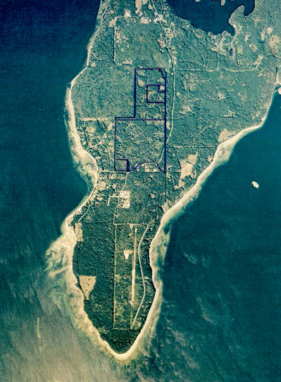
Photographs: On-site and Aerial
The
photographic documentation was completed during the site visit conducted
November 12 and 13, 2002, and is appended to this document in Exhibit D. In
addition, an aerial photograph of the Property taken in 2001 is appended in
Exhibit C.
The
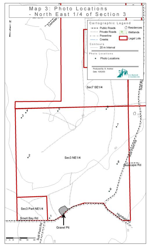
locations of the photographs are detailed on Map 3 with the numbers 1 to and
including 9 thereon corresponding to the locations at which photographs were
taken.
VIII. Maps
The
following four maps of the Property are attached to this report in Exhibit A:
Map 1: Traverse Route and
Plot Location
Map 2: Ecosystem Polygons
Map 3: Photo Locations
Map 4: Wildlife Polygons
Disclaimer:
Cartographic information including Property boundaries, road locations, power
lines, streams, and contours from Weyerhaeuser Company Ltd. GIS databases,
obtained through Olympic Resource Management, Vancouver, B.C. Polygon
boundaries, plot locations, traverse routes, waterlines, and refined stream
locations based on consultants field estimations. These are not surveyed
locations.
IX.
Recommended Monitoring
This Property should be monitored
for compliance with the Conservation Covenant once per year at a minimum.
X.
Caveat
To the
extent that this document conflicts with the Conservation Covenant, the text of
the fully executed Conservation Covenant shall control.
XI.
References
Banfield,
A. W. 1974. The mammals of Canada. University of Toronto Press. 438 pp.
B.C. Conservation Data Centre. 2001. Tracking lists for the
Campbell River, Sunshine Coast, and Mid Coast Forest Districts. B.C. Min. of
Sustain. Res. Manage., Victoria.(http://srmwww.gov.bc.ca/cdc/tracking.htm).
B.C. Conservation Data Centre. 2001. Element occurrence
database. BC Min. of Sustain. Res. Manage., Victoria.
B.C. Min. of Env., Lands, and Parks, and B.C. Min. For.
1998. Field manual for describing terrestrial ecosystems. Land Manage. Handbk.
No. 25. Victoria, B.C.
Campbell, R.W., Neil K. Dawe, Ian McTaggart-Cowan, John M.
Cooper, Gary W. Kaiser and Michael C. E. McNall. 1990. The birds of British
Columbia Vol. 1. UBC Press, Vancouver, BC.
Campbell, R.W., Neil K. Dawe, Ian McTaggart-Cowan, John M.
Cooper, Gary W. Kaiser and Michael C. E. McNall. 1990. The birds of British
Columbia Vol. 2. UBC Press, Vancouver, BC.
Campbell, R.W., Neil K. Dawe, Ian McTaggart-Cowan, John M.
Cooper, Gary W. Kaiser Michael C. E. McNall and G.E. John Smith. 1997. The
birds of British Columbia Vol. 3. UBC Press, Vancouver, BC.
Campbell, R.W., Neil K. Dawe, Ian McTaggart-Cowan, John M.
Cooper, Gary W. Kaiser, Andrew C. Stewart and Michael C. E. McNall. 2001. The
birds of British Columbia Vol. 4. UBC Press, Vancouver, BC.
Cannings, Sydney G., Leah R. Ramsay, David F. Fraser, and
Mark A. Fraker. 1999. Rare amphibians, reptiles, and mammals of British
Columbia. Wildl. Branch and Resour. Inv. Branch, B.C. Ministr. Environ., Lands
and Parks, Victoria, BC. 198 pp.
Committee on the Status of Endangered Wildlife in Canada.
2002. Database of designated species. Gov. of Canada, Ottawa
(http://www.cosewic.gc.ca/cosewic/eng/sct1/index_e.htm).
Fraser, David, F., William L. Harper, Sydney G. Cannings,
and John M. Cooper. 1999. Rare birds of British Columbia.Wildl. Branch and
Resour. Inv. Branch, BC Ministr. Environ., Lands and Parks, Victoria, BC. 244
pp.
Green, David M. and R. Wayne Campbell. 1984. The amphibians
of British Columbia. Royal British Columbia Museum Handbook no. 45., Victoria,
BC.
Green, R.N. and K. Klinka. 1994. A field guide to site
identification and interpretation for the Vancouver Forest Region. B.C. Min.
For., Land Management Handbook No. 28, Victoria, B.C.
Maser, Chris. 1998. Mammals of the Pacific Northwest. Oregon
State University Press, Corvalis, OR.
Nagorsen, David W., 1996. Opposums, shrews and moles of
British Columbia. UBC Press, Vancouver, BC. 169 pp.
Nagorsen, David, W. and R. Mark Brigham. 1993. Bats of
British Columbia. UBC Press, Vancouver, BC.
Straley, G.B., R.L. Taylor & G.W. Douglas. 1985. The
rare vascular plants of British Columbia. Syllogeus (Ottawa) No. 59: 1-165.
Wildlife Tree Committee of British Columbia. 2000.
Wildlife danger tree assessor’s course Handbook. 6th Edition.
EXHIBIT
"A"
Maps
EXHIBIT
"B"
Vegetation
List
Understory plant species observed in plot data
|
|
Common Name
|
|
Alnus rubra
|
red alder
|
|
Anaphalis margaritacea
|
pearly everlasting
|
|
Cornus canadensis
|
bunchberry
|
|
Cytisus scoparius
|
Scotch broom
|
|
Dicranum fuscescens
|
dusky fork moss
|
|
Galium trifidum
|
small bedstraw
|
|
Galium triflorum
|
sweet-scented bedstraw
|
|
Gaultheria shallon
|
salal
|
|
Grass spp.
|
grass
|
|
Hieracium albiflorum
|
white-flowered hawkweed
|
|
Holodiscus discolor
|
oceanspray
|
|
Hylocomium splendens
|
step moss
|
|
Kindbergia oregana
|
Oregon beaked moss
|
|
Linnaea borealis
|
twinflower
|
|
Mahonia nervosa
|
dull Oregon-grape
|
|
Pinus contorta
|
lodgepole pine
|
|
Polystichum munitum
|
sword fern
|
|
Pseudotsuga menziesii
|
Douglas-fir
|
|
Pteridium aquilinum
|
bracken fern
|
|
Rosa gymnocarpa
|
baldhip rose
|
|
Rubus discolor
|
Himalayan blackberry
|
|
Rubus spectabilis
|
salmonberry
|
|
Rubus ursinus
|
trailing blackberry
|
|
Scapania bolanderi
|
yellow-ladle liverwort
|
|
Thuja plicata
|
western redcedar
|
|
Tsuga heterophylla
|
western hemlock
|
|
Vaccinium parvifolium
|
red huckleberry
|
EXHIBIT
"C"
Aerial
Photograph
EXHIBIT
"D"
Photographic
Documentation
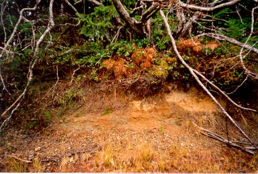
Photo 1: Profile of
the soil in the gravel pit on Sutil Point Road near the south end of the
property. Coarse soils result in a dry site with low productivity Douglas-fir
and salal.
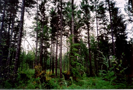
Photo 2: Forest type
around plot KH4, showing a small patchcut through a forest screen.
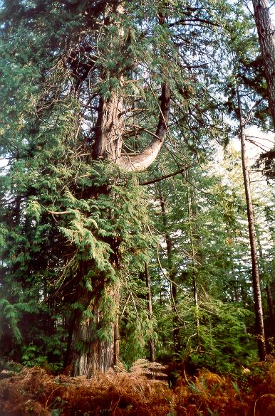
Photo 3: Old western
redcedar near the NW corner of the property.
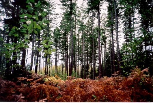
Photo 4: Thinned
young forest near the NW corner of the property. Increased soil moisture is
evident here with development of some deciduous shrubs in the understory
community.
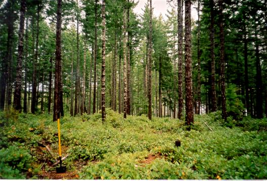
Photo 5: The
northern portion of the property here is a broad gentle well-drained crest with
a thinned young forest. This is a drier portion of ecosystem polygon 2.
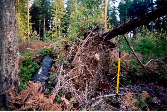
Photo 6: Root
profile from a windthrown tree in ecosystem polygon 2, near boundary with
polygon 3. This profile shows a “flattened off” base indicating root
restricting soil moisture at depth.
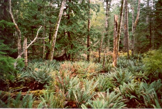
Photo 7: View of
vegetation in ecological polygon 3. More western redcedar, red alder, ferns
and shrubs are indicative of increasing soil moisture and nutrients. This site
is nearly site series 07.
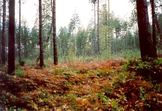
Photo 8: View of
vegetation in a more zonal portion of ecological polygon 3 with a patchcut
behind.
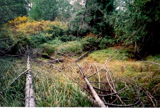
Photo 9: View of
vegetation in ecological polygon 4. This small depression near Sutil Point
Road is dominated by sedges but is not large enough to be an important habitat
feature.
END OF DOCUMENT