200 - 163 West Hastings St. • Vancouver, BC • V6B 1H5 • Canada
Contact: Renewal • 1-604-844-7474
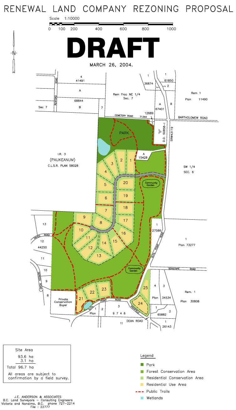
SOUTH END PROPOSAL
RLCÍs South End proposal encompasses three contiguous properties, totaling approximately 98 hectares. The properties are bounded by Cemetery Road to the north, Sutil Point Road to the east and south and Hayes Road and the Sliammon Indian Reserve to the west. The forest is primarily mature second-growth Douglas-fir, with some western red cedar, pine and western hemlock.
RLC has applied to rezone these properties to Forest Land Stewardship to allow a maximum of 25 strata lots, as well as conservation, selection logging, public trails and parkland.
Click here to see a map of the proposed site design.
We hope to complete the rezoning process by the end of 2004 and have strata lots available by summer 2005.
Forest Conservation Areas
RLCÍs goal is to protect biodiversity and the forest ecosystem, while preserving the long-term sustainable forestry potential on these lands. The South End proposal includes a large Forest Conservation Area, the use of which will be governed in part by a conservation covenant, held by The Land Conservancy of BC.
Public Trails and Parkland
Another goal for RLC is to promote public access, as appropriate, on suitable private lands. Public access and recreation will be encouraged on South End properties through the creation of a network of public trails, and the donation of a Regional Park near the MansonÍs Area. RLC hopes that over time, as the MansonÍs core develops, this permanently protected area will provide both a basis and an impetus for the future development of greenspace and trail systems on adjacent properties and throughout the MansonÍs Landing area. RLC also hopes that the establishment of this public trail network will act as a catalyst to encourage other private landowners, as appropriate, to allow public access to existing trails on their lands.
Residential Use Areas and Residential Conservation Areas
RLC is currently seeking a rezoning that will permit the creation of up to twenty-five residential strata lots under a bare land strata subdivision. Conservation covenants will prohibit the future creation of any additional lots. Proposed strata lots are clustered in order to minimize the ecological impact on the land, make use of existing road infrastructure, spread the concentration of population around existing neighborhoods and infrastructure and minimize fragmentation of the Forest Conservation Area.
Each strata lot will include a maximum 0.8 hectare (2-acre) Residential Use Area in which residential clearing, residential dwellings and outbuildings, and associated residential activities will be permitted Residential Use Areas will have a minimum 15-metre setback from lot lines and roads in order to increase privacy for landowners and reduce the aesthetic impact for existing neighbours. The remainder of each strata lot will be designated as a Residential Conservation Area.
Principles to Help Minimize the Ecological Footprint of Residential Development
RLC has adopted ïSmart GrowthÍ measures as much as possible to minimize the ecological impact of residential development, including:
• Mix land uses;
• Take advantage of compact building design;
• Create a range of housing opportunities and choices;
• Create walkable neighbourhoods;
• Foster distinct, attractive communities with a strong sense of place;
• Preserve open space, farmland, natural beauty and critical environmental areas;
• Strengthen and direct development towards existing communities;
• Provide a variety of transportation choices;
• Make development decisions predictable fair and cost effective; and,
• Encourage community and stakeholder collaboration in development decisions.
The
charts below summarize the South End proposal.
Summary of RLC SOUTH END SITE PLAN: March 26th 2004 Draft
The following numbers are associated with the DRAFT South End rezoning proposal map
PART ONE: Proposed Forest Land Stewardship zoning, Lots 1-23 on attached map
above. (93.6 hectares, 231 acres)
|
PUBLIC PARK |
FOREST CONSERVATION AREA |
RESIDENTIAL USE AREA |
RESIDENTIAL CONSERVATION AREA |
ROADS |
TRAILS (KM) |
TOTAL AREA FOR CONSERVATION PURPOSES |
TOTAL AREA FOR RESIDENTIAL PURPOSES |
SIZE: HECTARES (ACRES) |
12.2
(30) |
45.7
(113) |
18.4
(45) |
14.9
(37) |
2.4
(6) |
7.5 |
57.9ha
(143 acres) |
33.3ha
(82 acres) |
PERCENT OF TOTAL AREA |
13 |
49 |
20 |
16 |
2 |
n/a |
62% |
36% |
MANAGEMENT |
Conservation, recreation and public access |
Selection logging and conservation |
Residential use |
Selection logging and conservation |
Private access |
Recreation and public access |
|
|
NOTE: All figures are approximate. Land has not been surveyed. |
PART TWO: Proposed Residential Zoning; Lots 24 & 25 on attached map
above.(3.1 hectares, 7.7 acres)
|
RESIDENTIAL USE AREA |
RESIDENTIAL CONSERVATION AREA |
ROADS |
Quick Links to Renewal Properties
See the overall map of Cortes Island that includes all RLC's properties
|
SIZE:HA.
(ACRES) |
1.6
(4) |
1.5
(3.7) |
0 |
PERCENT OF TOTAL AREA |
52 |
48 |
n/a |
MANAGEMENT |
Residential use |
Selection logging and conservation |
n/a |
NOTE: All figures are approximate. Land has not been surveyed. |